| Ref No | LDGSL/729 |
| Title | Geological map of New South Wales, Australia |
| Date | 1834 |
| 1838 |
| Level | Item |
| Extent | 1 map |
| Format | Map/section |
| Description | Geologically coloured map of New South Wales, Australia, by Thomas Livingstone MITCHELL, 1838. Base map is Mitchell's own 'Map of the Colony of New South Wales', 1834, scale: 1 inch to 9 miles. 132.5cm x 62.5cm.
Mitchell described it as being, "...a map of the settled part of the colony of New South Wales on which I have endeavoured to shew the situation of the principal rocks, in further illustration of some passages in the book I have lately published on that country" (letter of 6 November 1838, GSL/L/R/4/49). |
| Thumbnail | 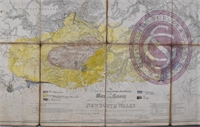
|
| Provenance | Presented by Thomas Mitchell, 6 November 1838 (see letter GSL/LR/4/49) |
| Access Conditions | Access is by appointment only. Please contact the Archivist for further information. |
| Language | English |
| ArchNote | Description by John Thackray |
| CreatorName | MITCHELL | Sir | Thomas Livingstone | 1792-1855 | surveyor and explorer in Australia |