| Ref No | LDGSL/404 |
| Title | Geological maps and sections of the mining district of Cornwall |
| Date | 1819 |
| Level | File |
| Extent | 3 printed sheets |
| Format | Map/section |
| Description | Richard THOMAS, hand coloured engravings of:
1) 'Geological map of the mining district of Cornwall between Camborne and Chasewater shewing the lodes, cross courses, adits, &c', published by John Cary, 1 July 1819.
2) ‘Geological sections in illustration of the map of the mining district of Cornwall' - transverse & longitudinal, published by John Cary, 1 July 1819.
3) 'Geological view of the mining district of Cornwall, corresponding with the map of Chasewater to Camborne shewing the Elevations of the Hills and the depths to which the Mines are extended', published by John Cary, 1 July 1819. |
| Thumbnail | 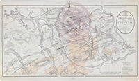
|
| Provenance | Presented by John Taylor. |
| Access Conditions | Access is by appointment only. Please contact the Archivist for further information. |
| Language | English |
| Related Material | The sections, including a later version of the 'Geological view...' published in 1824, can be found at: LDGSL/746, bound alongside William Smith's Geological Sections; see Tract E136 for report on the geological map; archive also hold Greenough's copy of the map at LDGSL/947/6/D/11/10. |
| Publication Note | Published as part of: Thomas, Richard, 'Report On A Survey Of The Mining District Of Cornwall From Chasewater To Camborne' (1819). |
| ArchNote | Description by John Thackray, revised by Caroline Lam |
| CreatorName | THOMAS | Richard | 1779-1858 | civil engineer |
| CARY | John | 1755-1835 | cartographer |
| Subject | Veins |
| Mine & Quarry plans |
| Mining sections |
| Copper mining |
| Tin mining |
| Term | Mining |
| Previous reference | LDGSL 404 |