| Ref No | LDGSL/510b |
| Title | Geological map of the Isle of Wight |
| Date | 1815 |
| Level | Item |
| Extent | 1 map |
| Format | Map/section |
| Description | 'Geological Map of the Isle of Wight and the adjacent parts of Hampshire and Dorsetshire', delineated by Thomas Webster, engraved by J Walker and published by Payne & Foss, Pall Mall, [London], 1815. Hand colouring on printed base map. |
| Thumbnail | 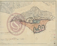
|
| Provenance | Donated to the Library by Edward Bromhead, December 2014. |
| Access Conditions | Access is by appointment only. Please contact the Archivist for further information. |
| Language | English |
| Related Material | Map is taken from: Englefield, H. 'Description of the principal picturesque beauties, antiquities and geological phenomena of the Isle of Wight'. London: printed by W Bulmer & Co for Payne and Foss, 1816. (plate 50). |
| ArchNote | Description by Caroline Lam |
| CreatorName | WEBSTER | Thomas | 1772-1844 | geologist |