| Ref No | LDGSL/751 |
| Title | 'Stratification in Hackness Hills' |
| Date | 1832 |
| Level | File |
| Extent | 1 map |
| Format | Map/section |
| Description | Geological map, 'Stratification in Hackness Hills', with manuscript colouring by William SMITH, 1832. Scale: 6 ½ inches to 1 mile. The base map was lithographed by W Day, 17 Gate Street, Lincoln Inn Fields, London. c.60 x 95cm |
| Thumbnail | 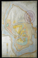
|
| Administrative History | The map was created whilst William Smith was land steward to Sir John V B Johnstone, Bart, of Hackness, 1828-1834. |
| Provenance | Given to the Society on 16 May 1917 by Thomas Sheppard, one of two copies he stated that he managed to locate, see: Sheppard, T, "A Lecture on British Geological Maps as a Record of the Advance of Geology", 'Proceedings of the Geological Society', 16 May 1916. Also see letter referencing the map in CM papers, 23 June 1943 (CM/9/5). |
| Access Conditions | Access is by appointment only. Please contact the Archivist for further information. |
| Language | English |
| Publication Note | A copy of the accompanying memoir is published in: Sheppard, T, "William Smith, his maps and memoirs", 'Proceedings of the Yorkshire Geological Society', vol 19 (1920), Appendix C, pp223-232, and also in Fox-Strangways, C, 'The Jurassic Rocks of Britain, vol 1', Memoir of the Geological Survey of Great Britain (1892), pp507-513; Map is referred to in Eyles, J M. "William Smith, a bibliography...", 'Journal of the Society for the Bibliography of Natural History', vol 5 (1969), pp87-109, item 38. |
| ArchNote | Description by John Thackray, revised by Caroline Lam |
| CreatorName | SMITH | William | 1769-1839 | civil engineer and geologist |
| Previous reference | LDGSL 751 |