| Ref No | LDGSL/750 |
| Title | Geological colouring on 'A map of the country round Scarborough...' |
| Date | 1821 |
| 1831 |
| Level | File |
| Extent | 1 map |
| Format | Map/section |
| Description | Geological colouring by William SMITH, 1831, on base map 'A map of the country round Scarborough in the North and East Ridings of Yorkshire from actual trigonometrical survey with topographical geological and antiquarian descriptions by Robert Knox of Scarborough, published June 1, 1821'. Signed and dated by Smith on the bottom right hand corner. Mounted on cloth and sectioned.
Note: Previous catalogue stated that the map has marginal annotations but attributed these incorrectly to George Bellas Greenough. The marginalia is not in Greenough's hand, and is in fact likely to be contemporary with the colouring of the map as other than these notes, there is no key. |
| Thumbnail | 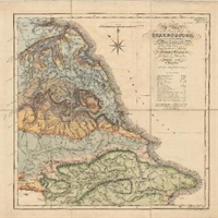
|
| Provenance | The map may have been acquired sometime between 1846-1856, that is it does not appear in the printed Library catalogue of 1846, but is included in the 1856 supplement. |
| Access Conditions | Access is by appointment only. Please contact the Archivist for further information. |
| Language | English |
| Related Material | There are at least two copies of this map in the Smith archives in Oxford Museum of Natural History, one of which is a rough, draft copy [information from John Henry, December 2014]. |
| ArchNote | Description by John Thackray; revised by Caroline Lam |
| CreatorName | SMITH | William | 1769-1839 | civil engineer and geologist |